Types of Clouds
We often feel amazed looking at the sky and how it changes patterns over day and night. This happens due to the formation of clouds that we see above us. Clouds are collections of tiny droplets of water or ice crystals that are found suspended in the atmosphere.
There are different types of clouds based on the height where they are found and the characteristics they show. If you have noticed, the pattern of clouds in higher altitudes is different from that found near the sea-level. Also, clouds differ from one another based on seasons. Sometimes these differences help us predict a change in weather conditions. They also help to drive the water cycle in nature.
How Many Different Types of Cloud are There and What are They
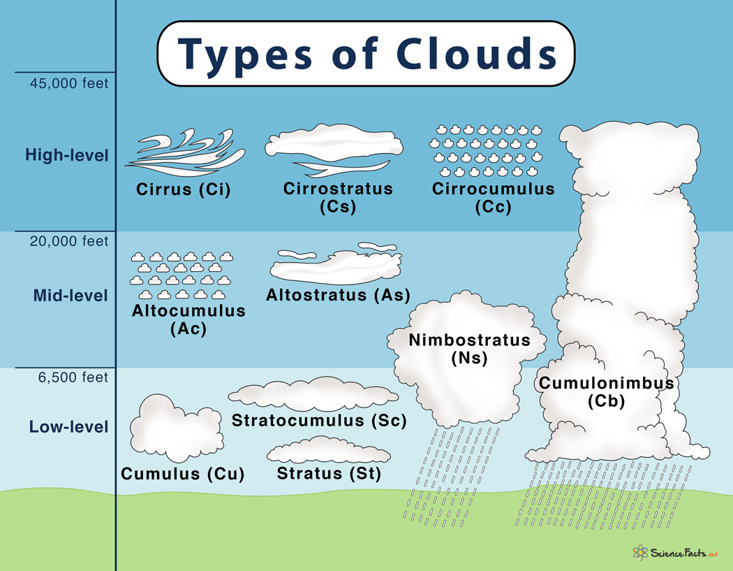
The present Latin-based international system for classifying clouds was introduced way back in 1803 by meteorologist Luc Howard. It was then adapted by the World Meteorological Organization (WMO) in their International Cloud Atlas that recognizes ten basic clouds ‘genera’; based on the height it forms in the sky and their appearance.
The ten basic cloud types are — 1. Cirrus (Ci), 2. Cirrostratus (Cs), 3. Cirrocumulus (Cc), 4.Altocumulus (Ac), 5. Altostratus (As), 6. Nimbostratus (Ns), 7.Cumulus (Cu), 8. Stratus (St), 9. Stratocumulus (Sc), and 10. Cumulonimbus (Cb).
How Do the Main Types of Clouds Form and What Do They Mean
Among the ten basic cloud types, nine are grouped into three levels based on the height they are found in the sky. Accordingly, clouds are named as high-level, middle-level, and low-level clouds. The remaining one cloud type is multi-level.
Given below are the characteristic features of each of the cloud types based on which they are identified:
High-level Clouds (Over 20,000 Feet)
These are the topmost clouds that are typically thin and white in appearance but can give other colors when the sun is low on the horizon during sunrise or sunset. High-level clouds are of three types:
1. Cirrus (Ci)
Cirrus are white, delicate, and feathery clouds that streak across the sky and are made of ice crystals. Their transparent nature depends on the separation of ice crystals due to wind currents.
These clouds occur in fair weather but can also be found ahead of large-scale storms like tropical cyclones and nor’easters.Cirrus are found before sunrise and after sunset appearing as bright yellow or red in color. During the daytime, they appear yellowish near the horizon, and after sunset becomes grayish. These clouds appear long before other clouds, and fade out much later as well.
What kind of weather they are associated with: A change in weather can be expected soon.
2. Cirrostratus (Cs)
Cirrostratus are transparent, whitish clouds with a hair-like appearance covering nearly the entire sky like the veil. They can be identified by seeing a halo (a circle or a ring of light) around the sun or moon.
Cirrostratus clouds are commonly seen in winters as there is much moisture in the upper atmosphere during that period. These clouds are also sometimes associated with approaching warm fronts.
What kind of weather they are associated with: Rain or snowfall
3. Cirrocumulus (Cc)
Cirrocumulus are small, white patches of clouds that look like regularly arranged grains or ripples. Cirrocumulus represents the degraded state of cirrus and cirrostratus and will show some characteristics of both of them.
These rare clouds are found in winter seasons when the atmosphere is bright and full of sunshine.
What kind of weather they are associated with: Fair but cold weather conditions. They may also indicate approaching a hurricane in tropical regions.
Mid-level Clouds (6,500-20,000 feet)
They are found below the high-level clouds and are mainly composed of water droplets. Mid-level clouds are also found to contain ice crystals when the temperature is low. Mid-level clouds are of three types:
1. Altocumulus (Ac)
Altocumulus are the most common mid-level clouds that can be identified by white or grey round patches covering the entire sky with parallel bands. These clouds are made of liquid water but often do not produce rain. Altocumulus are also known as ‘sheep backs’ and ‘mackerel skies’ because they look similar to the wool of sheep or scales of mackerel fish.
They are found during the hot and humid summer mornings.
What kind of weather they are associated with: They can indicate thunderstorms to come later in the day and are also seen ahead of cold fronts indicating the onset of winter.
2. Altostratus (As)
Altostratus are gray or blue-gray clouds that cover the entire sky partially or totally. Altostratus clouds are made of ice crystals and water droplets that are thin enough to allow sun rays to pass through them dimly but cannot form shadows in the ground.
These clouds form ahead of a warm or occluded front. Altostratus can also occur along with Cumulus during cold fronts.
What kind of weather they are associated with: Get prepared for a continuous spell of snowfall or rain.
3. Nimbostratus (Ns)
Nimbostratus are dark, grey clouds that cover the entire sky. They are diffused by falling rain snow and are thick enough to block sunlight.
These clouds are typical rain clouds seen during overcast conditions when steady rain or snow is falling or are about to fall.
What kind of weather they are associated with: Expect darkness with continuous rain or snowfall.
Low-level Clouds (less than 6,500 feet)
They are found closest to the earth’s surface and are composed of water droplets. Low-level clouds are mainly of three types:
1. Cumulus (Cu)
Cumulus are the symbol of clouds we use to draw and study during our childhood. They look like fluffy, white cotton balls in the background of a clear, blue sky. Cumulus clouds look beautiful during sunset and can be of varying shapes and sizes.
These clouds are formed on clear, sunny days when the sun rays reach and heat the earth’s surface. They are thus commonly called ‘fair weather’ clouds. Cumulus are observed during late morning hours and disappear by the evening.
What kind of weather they are associated with: They indicate fair weather.
2. Stratus (St)
Stratus are thin, flat, grayish sheets of clouds that cover the whole sky. Stratus seldom produces heavy rain because of their delicate nature but can appear as fog in mountain or hilly regions.
Stratus clouds are found during gloomy, overcast days.
What kind of weather they are associated with: Expect darkness with a slight drizzle.
3. Stratocumulus (Sc)
They are low, puffy, whitish or grayish clouds that occur in patches with blue sky between them. When observed from below, they often resemble a honeycomb appearance. Stratocumulus can be imagined if we think of cutting and spreading cumulus clouds unevenly across the sky.
Stratocumulus clouds are found mostly on cloudy days when there is a weak air current in the atmosphere.
What kind of weather they are associated with: Currently, a fair-weather, but a storm may be on its way.
Multi-level Towering Clouds (up to over 45,000 feet)
These are clouds found in low, middle, and sometimes even in high layers and thus are called multi-level clouds.
Cumulonimbus (Cb)
Also known as thunderstorm clouds, they are often being classified as low-level clouds. These clouds are found in all three layers – extending over several miles and often reaching high altitudes. Cumulonimbus looks like cumulus clouds from which they grow and assume towering shapes with bulging upper portions. The upper portion of these clouds is flat, smooth, and fibrous, whereas the lower portion is ragged, hazy, and dark.
Cumulonimbus clouds grow on hot days when warm, wet air rises high into the sky, resembling a mountain or a tower.
What kind of weather they are associated with: Expect heavy rainfall with thunderstorms and lightning. There is also a possibility of a flood. Look out for tornadoes as well.
Newer Types of Clouds
For the first time in more than 30 years, some new cloud types are added to the International Cloud Atlas by WMO. They have features that might somewhat be familiar to the clouds studied so far, while others that might look slightly different. Here is a list of these accessory clouds:
- Volutus: Commonly known as a ‘roll cloud’ by meteorologists, it is a typically rare, low-level, horizontal, tube-shaped cloud. Volutus are commonly associated with thunderstorms and sometimes with cold-fronts.
- Asperitas:It is a rare cloud that resembles a stormy ocean wavewhen viewed from underneath. Its appearance is often associated with convective thunderstorms that may occur afterward. However, it can also be found in relatively calm environments.
- Fluctus: A relatively short-lived wave formation found on the top surface of this cloud. It forms curls or breaking waves that are usually found to occur with Cirrus, Altocumulus, Stratocumulus, Stratus, and sometimes with Cumulus.
- Cavum: It is a well-defined cloud that is generally circular when viewed from below but may appear oval-shaped when viewed from a distance. When formed due to an aircraft’s interaction with the cloud, it appears linear, in the form of a dissipating trail. Cavum is found to occur with Altocumulus and Cirrocumulus and rarely with Stratocumulus.
- Murus: Commonly known as ‘wall cloud’, it is formed as a localized, persistent, and sudden lowering from the base of Cumulonimbus. Murus is often associated with a severe thunderstorm that typically develops in the rain-free portion of the Cumulonimbus.
- Cauda: Also known as ‘tail cloud’, it is a horizontal, tail-shaped supplementary cloud, found at low levels extending from the main precipitation region of Cumulonimbus to the Murus clouds. It is typically attached to the Murus, where both their bases are found at the same height. Cauda clouds are uncommon and are usually associated with severe thunderstorms.
- Flumen: Bands of low clouds associated with a supercell convection storm, Cumulonimbus. They are arranged parallel to the low-level winds and are moving towards the supercell thunderstorm. These accessory clouds are not attached to the wall cloud, and the cloud base is much higher than the wall cloud.,
- Flammagenitus: They are special cloudsthat originated due to convection initiated by localized forest fires, wildfires, or volcanic eruptions. These clouds must contain water droplets, at least in part.
- Homogenitus: These clouds originate from human activities, such as gases arising from thermal power plants.
- Homomutatus occurs when persistent contrails are found over a long time under the influence of strong winds, allowing them to grow and spread over a larger portion of the sky. These clouds continue undergoing internal transformation and eventually take on the appearance of natural cirri-form clouds.
- Cataractagenitus: Develops locally in the vicinity of large waterfalls when water breaks into spray by the falls. The motion of locally ascending air compensates the downdraft caused by the water current moving downwards.
- Silvagenitus: May develop locally over forests due to increased humidity formed by evaporation and transpiration from the trees.
FAQs
Ans. Yes, fog is a type of cloud that touches the ground.
Ans. Stratus, Cirrus, Cumulus, Stratocumulus, Nimbostratus, and Cirrostratus.
Ans. Thunderstorms arise from the Cumulonimbus or thunderstorm cloud.
Ans. Lenticularis, Nacreous, Asperitas, Kelvin-Helmholtz wave, Supercell storm cloud, Mackerel sky, Mammatus, Virga, and Fallstreak holes.
Ans. A mackerel sky describes Altocumulus clouds as they look similar to the scales of mackerel fish.
-
References
Article was last reviewed on Wednesday, November 18, 2020
Related articles


One thought on “Types of Clouds”
Leave a comment
Join our Newsletter
Fill your E-mail Address
This very helpful to me thank you.